Showing 150 items matching timber track
-
 Whittlesea Historical Society Inc.
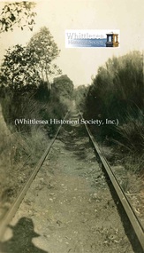
Photograph - Brown Album, Timber track Britannia, c. 1925
... Timber track Britannia...timber track... photograph: "Timber track Britannia". ...Timber track Britannia... Whittlesea melbourne Brown Album Photograph Timber track Britannia ...Digital image from Brown Album, p.3. Inscribed under photograph: "Timber track Britannia". Photographs in the Brown Album are of groups of family members and friends located in the areas of Whittlesea, Glenvale, Preston, Northcote, Jacks' Creek, Toorourrong Reservoir, Strathbogie, Mornington, Eltham, Heidelberg, 1926 Bushfires, Britannia Creek, WW1 Service men and camp, WW1 plane, groups of children and family homes they lived in.Digital JPG file Scan of black and white photo from Brown AlbumTimber track Britannia1926, brown album, britannia creek, timber track -
 Marysville & District Historical Society
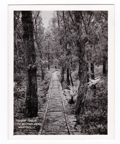
Photograph (item) - Black and white photograph, Timber Track to Michaeldene, Marysville, 1923-1963
... Timber Track to Michaeldene, Marysville...timber track...An early black and white photograph of an old timber track...An early black and white photograph of an old timber track... photograph Photograph Timber Track to Michaeldene, Marysville ...An early black and white photograph of an old timber track that leads to the Michaeldene track.An early black and white photograph of an old timber track that leads to the Michaeldene track. The Michaeldene Walking Track is a popular walking track near Marysville in Victoria. Sections of this mostly flat circuit follow old tramline alignments, which in places reveal the original timber sleepers on which the big logs were transported to the nearby sawmill. This photograph was published by the Valentine Publishing Co. Pty. Ltd. as a souvenir of Marysville.timber track, michaeldene track, walking track, marysville, victoria, souvenir, timber tramway -
 Marysville & District Historical Society
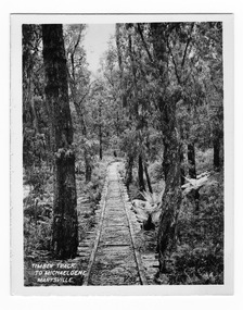
Photograph (item) - Black and white photograph, Valentine Publishing Co. Pty. Ltd, Timber Track to Michaeldene, Marysville, 1923-1963
... Timber Track to Michaeldene, Marysville...timber track...An early black and white photograph of an old timber track...An early black and white photograph of an old timber track... photograph Photograph Timber Track to Michaeldene, Marysville ...An early black and white photograph of an old timber track that leads to the Michaeldene track.An early black and white photograph of an old timber track that leads to the Michaeldene track. The Michaeldene Walking Track is a popular walking track near Marysville in Victoria. Sections of this mostly flat circuit follow old tramline alignments, which in places reveal the original timber sleepers on which the big logs were transported to the nearby sawmill. This photograph was published by the Valentine Publishing Co. Pty. Ltd. as a souvenir of Marysville.timber track, michaeldene track, walking track, marysville, victoria, souvenir, timber tramway -
 Lorne Historical Society
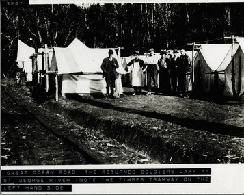
Photograph, The Returned Soldiers Camp at St. George River
... Returned-Soldiers-Camp; St.-George-River. Timber-Tramway...-River. Timber-Tramway-Track ...Six workmen and cook? near tents at St George River Returned Soldiers' Camp. Note timber tramway on left-hand side of photographreturned-soldiers-camp; st.-george-river. timber-tramway-track -
 Marysville & District Historical Society
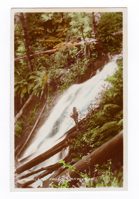
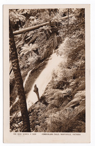
Photograph (item) - Colour tinted photograph, Valentine Publishing Co. Pty. Ltd, Cumberland Falls, Marysville. No.3, 1923-1963
... point road eucalyptus regnans big culvert yarra track timber ...An early colour tinted photograph of the Cumberland Falls near Marysville in Victoria. This photograph was published by the Valentine Publishing Co Pty. Ltd. as a souvenir of Marysville.An early colour tinted photograph of the Cumberland Falls near Marysville in Victoria. These falls are located on the Marysville-Wood's Point Road. Cambarville is notable for its giant mountain ash (Eucalyptus regnans) trees within the Cumberland Memorial Scenic Reserve, and relics from former sawmills and gold mining. The Big Culvert is located nearby on the Marysville-Woods Point Road, which was historically part of the Yarra Track. Cambarville was established as a timber mill town in the 1940s. Timber mill owners A Cameron and FJ Barton named Cambarville. They established the mill to salvage timber from trees destroyed in the 1939 bushfires. Cambarville was impacted by the 2009 Black Saturday bushfires and any remaining structures were destroyed.cumberland falls, waterfalls, marysville, victoria, valentine publishing co, souvenir, a cameron, fj barton, cambarville, marysville-wood's point road, eucalyptus regnans, big culvert, yarra track, timber milling, 1939 bushfires, black saturday bushfires -
 Marysville & District Historical Society
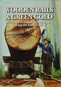
Book - Hardcover book, Peter Evans, Wooden Rails & Green Gold-A century of timber and transport along the Yarra Track, 2022
... Track from Narbethong to Matlock A history of the timber mills ...A history of the timber mills along the Yarra Track from Narbethong to Matlock.Hardcover. Shows Mick Taylor making last-minute adjustments to the rigging of a large log about to commence its journey down the incline to the Marysville Timber and Seasoning Company No.1 mill. Back cover has a photograph of a rail tractor towing a timber trolley along a timber tramway.non-fictionA history of the timber mills along the Yarra Track from Narbethong to Matlock.timber, timber mills, yarra track, narbethong, matlock, marysville, wood's point, wilks creek, great divide, cathedral range, cumberland, foresters, sawmillers, peter evans -
 Marysville & District Historical Society
Book - Hardcover book, Peter Evans, Wooden Rails & Green Gold-A century of timber and transport along the Yarra Track, 2022
... Track from Narbethong to Matlock. A history of the timber mills ...A history of the timber mills along the Yarra Track from Narbethong to Matlock.Hardcover. Shows Mick Taylor making last-minute adjustments to the rigging of a large log about to commence its journey down the incline to the Marysville Timber and Seasoning Company No.1 mill. Back cover has a photograph of a rail tractor towing a timber trolley along a timber tramway.non-fictionA history of the timber mills along the Yarra Track from Narbethong to Matlock.timber, timber mills, yarra track, narbethong, matlock, marysville, wood's point, wilks creek, great divide, cathedral range, cumberland, foresters, sawmillers, peter evans -
 Eltham District Historical Society Inc
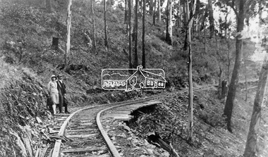
Negative - Photograph, Timber Tramway at Wright's Falls, Kinglake District, c.1920
... Man and woman stand beside timber tramway track at Wright's... stand beside timber tramway track at Wright's falls Kinglake ...Man and woman stand beside timber tramway track at Wright's falls Kinglake. The tramway was constructed alongside the road to support the large traffic in firewood between the mountains to Whittlesea. The Wright family owned the land on which the Falls were situated and were sold for a penny an acre according to a Wright family story. This photo forms part of a collection of photographs gathered by the Shire of Eltham for their centenary project book,"Pioneers and Painters: 100 years of the Shire of Eltham" by Alan Marshall (1971). The collection of over 500 images is held in partnership between Eltham District Historical Society and Yarra Plenty Regional Library (Eltham Library) and is now formally known as 'The Shire of Eltham Pioneers Photograph Collection.' It is significant in being the first community sourced collection representing the places and people of the Shire's first one hundred years.Digital image 4 x 5 inch B&W Negshire of eltham pioneers photograph collection, kinglake, timber tramway, wrights falls -
 Melbourne Tram Museum
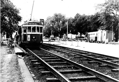
Photograph - Set of two Black & White Photograph/s, 1950's? to 1960's
... timber sleepered track, temporary huts, a transport bus, air...'s or early 1960's. Shows timber sleepered track, temporary ...Black and white photograph of trams on temporary track in St Kilda Road, Melbourne, late 1950's or early 1960's. Shows timber sleepered track, temporary huts, a transport bus, air compressor and temporary barriers and kerosene lamps. .1 - W2 379 outbound on temporary track, destination of Malv Tn Hall (Malvern Town Hall) route 6B. .2 - W2 262, followed by 775 and two other trams. W2 has the destination of East Malvern Darling Road, Route 4D. Printed on Fujichrome paper. Not known who took the photograph or when it was printed.Stamped in black ink on back "TMSV Sales"trams, tramways, st kilda rd, temporary track, reconstruction, malvern town hall, darling rd, tram 379, tram 262, tram 775 -
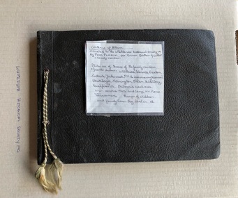 Whittlesea Historical Society Inc.
Album - Photograph, Brown Album, c.1925
... women, Strathbogie 3. Timber track Britannia 4. Two girls.... Whittlesea Show 2. Three women, Strathbogie 3. Timber track Britannia ...Album of personal photographs of family members, friends, groups of children, and areas of Whittlesea, Glenvale, Preston, Northcote, Jack's Creek, Strathbogie, Mornington, Eltham, Heidelberg, Britannia Creek, WW1 service men and camp and a defence plane. Page 1 1. Remains of School after fire Britannia Creek 1926 2. Result of Bushfire Britannia Creek Creek 1926 3. Fish pond destroyed by fire 1926 4. Children Britannia Creek 1926 Page 2 1. Three men and a boy after the bushfire Britannia Creek 1926 2. Men and a car, Mentone, J. Gollary, Tom O' Connor 3. Dog and a kennel, "Brownie", Preston 1925 4. Group of children, "An apple a day", Britannia Creek 1926 Page 3 1. Whittlesea Show 2. Three women, Strathbogie 3. Timber track Britannia 4. Two girls sitting, "In the right mood" 5. 9th Patrol Preston ? Bruthen Page 4 1. The moon 2. House and fence, St George's Road, Northcote 3. Biplane, A Defence Plane 4. Close up, plane landed, service men looking at plane, "A close up view" Page 5 Top of page, "Dranold" Hawking St, Preston 1. House with fence, "House" 2. Garden right side 3. Garden left side 4. Man in garden holding a watering can, "Back garden" Page 6 Four photos of Kinglake 1. Fern Gully Plenty Ranges 2. Plenty Ranges 3. Mt Disappoinment 4. Road through water shed Page 7 1. View of Whittlesea Township 2. Eel pond, Glenvale 3. Haymaking, "Stacking", Glenvale 4. Harvesting Glenvale Page 8 Four photos of creeks 1. Jack's Creek 2. Jack's Creek and shed (this looks like the Toorourrong Reservoir 3. A barrel in the water, "Bruce's Creek" 4. Water running over rocks, "Bruce's Creek" Page 9 1. Horse and rider with 2 men, Whittlesea 2. View from Mt Hope looking South Glenvale 3. Cricket Ground Heidelberg 4. View of a cliff, bottle necked swallow's nests Page 10 "Eltham Cup Day" at top of page 1. Norm and Syd - men playing cricket 2. Ralph - playing cricket 3. Norm and Syd - playing cricket Page 11 1. 8 boys - Preston B Baseball Team 2. Group of men - Eltham 3. Woman standing - V. Townsend 4. Horse and Wagon - WW1 Williamstown Camp, C. Jose Page 12 1. Man sitting on bricks - Stan 2. School boy - He? F Greenough 3. Boy posing with baseball bat 4. Ted Cecil Page 13 1. 2 woman, 2 men standing in bush setting - "The Grants" 2. Woman standing on a hill overlooking a township below 3. View of water - "Mornington" 4. A house - "Mornington" Page 14 Strathbogie 1. Man standing outside a wooden building 2. Man standing outside a wooden building having a wash 3. Girl and boy 4. 3 children standing next to a wooden house Brown coloured, detachable leaf paste-in photo book, 7 loose pages, cord threaded through eyelets on the left side. Photographs pasted on to both sides of pages. Total of 56 photos, black and white. Descriptions handwritten above or below each photo. Some of the photos dated 1925 and 1926. Inscribed on the front of the album, "The Warwick Album"whittlesea, britannia creek, glenvale, jack's creek, strathbogie, ww1, service men, j gollary, tom o'connor, dog and kennel, 1853, whittlesea show, 9th patrol preston, defence plane, st george's road, northcote, preston, dranold hawking steet preston, kinglake, mount disappointment, plenty ranges, fern gully plenty ranges, haymaking, gkenvale, harvesting glenvale, whittlesea township, toorourrong reservoir, bruce's creek, mt hope, cricket ground heidelberg, horse, eltham cup day, cricket, norm and syd, preston b baseball team, v townsend, horse and wagon, ww1 williamstown camp, c jose, ted cecil, stan, mornington, the grants -
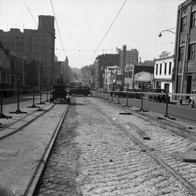 Melbourne Tram Museum
Negative - Set of 2, Possibly Geoff Grant, c1950
... . Photo shoes the method of track construction - timber sleepers.... Photo shoes the method of track construction - timber sleepers ...Set of two Black and white negatives of track construction in La Trobe St during 1950. .1 - Looking east from Queen St. Has the Argus building in the view. Both tracks have been constructed and the concrete foundation poured pending the top asphalt layer, a building selling Skoda cars, .2 - Looking west from Queen St with a tram crossing in the background in William St. Photo shoes the method of track construction - timber sleepers with the rail bolted to the sleeper. Pending concerting. In the background is The Mint and terrace houses on the left. There is a billboard for 1949 movie, "The Bribe". Photo not in Wal Jack Melbourne album.trams, tramways, la trobe st, track construction, trackwork, queen st -
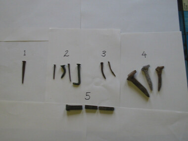 Parks Victoria - Gabo Island Lightstation
Nails
... nails. Used to pin railway track to timber sleepers and decking... nails. Used to pin railway track to timber sleepers and decking ...The five types of nails include a stamped steel nail made for wooden flooring; four copper nails used for boat building found at various locations on the island; two steel nails removed from the lantern room door during restoration in 2002 which possibly came with the Chance Bros. lantern room kit delivered in 1862; three galvanised steel nails used to pin the railway track to sleepers and decking on the jetty (the rail track carried a small trolley for unloading stores from supply ships); and a square copper nail found on the rocky shore on Tullaberga Island close to the location of the Monumental City wreck of 1853. The huge American steamer, Monumental City, was wrecked on 15 May 1853. Built in 1850, the ship was the first screw-propulsion steamer to cross the Pacific and was heading back to Sydney after dropping off Californians heading for the Victorian goldfields. Thirty-seven lives were lost, including the owner of the ship, Peter Strobel. A medal was awarded by Sydney residents to Charles Plummer who swam ashore with a line from the wreck. The tragedy renewed the urgency for a lighthouse on Gabo Island, and in 1862 when this was achieved an obelisk was erected as a memorial to those who perished. That year, Victorian PWD architect and designer of the lightstation buildings, Charles Maplestone, gave the following instructions: ‘You may remove the remains of the poor unfortunate shipwrecked of the Monumental City to the site on Gabo you propose but take scrupulous care to collect all the remains and inter them decently under the monument. Pray save any relics’.246 Heritage Victoria has 39 artefacts listed under the Historic Shipwrecks Act (S473) with a clear provenance to the Monumental City. While the copper nail has no documented provenance, it still has contributory significance as part of a diverse assemblage of relics that help to interpret the history of the Gabo Island Lightstation and the numerous shipwrecks that have occurred in its vicinity since the mid nineteenth century..1 Steel nail - flat. Stamped. This type of nail was used for secret nailing of flooring. Source of this nail is unknown. .2 Copper nails. This type of nail was used for boat building. Found at various locations around island. .3 Steel nails. Extracted from lantern room door during restoration 2002. .4 Galvanised steel nails. Used to pin railway track to timber sleepers and decking on jetty. Rail track carried a small trolley used during the unloading of stores from supply ships. .5. Copper nail square. This nail was found on the rocky shore line on Tullaberga Island close to the location of the wreck of the "Monumental City" wrecked May 1853. Nail found in June 2000. -
 The Beechworth Burke Museum
Photograph, 1910
... . There is a small timber structure on the right of the image which could.... There is a small timber structure on the right of the image which could ...This photograph dating to 1910 depicts an open cut sluicing site located in El Dorado captured looking east up the open cut from the number 3 Barge site. Sluicing was undertaken in the area from 1900 to 1942 with some short breaks between these periods. The image depicts a location mined by Cocks Pioneer Gold and Tin Sluicing Company (as recorded on the annotation on the card mount). It portrays open cut rocks with a crevice in the center of the image where the sluicing was being undertaken. There is a small timber structure on the right of the image which could be an entrance to a mine or supports made of wood to prevent a cave in at the open cut site and above the cut rock there is bush. The timber structure has rail tracks on top of the bridge which could suggest the identification of this structure as a mine entrance. The rail tracks were used for little carts which hauled soil from the mine. The Cocks Pioneer Gold and Tin Mines N.L was one of El Dorado's two largest open cut sluicing mines of the 20th Century. The other was named the Cocks El Dorado Gold Dredging Company. The Cocks Pioneer Mines operated from 1901 until 1941 and found a total of 117,378 ounces of Gold and 1,673 tones of tin concentrates over these years. The Cocks company was formed in 1898 and operated until 1941. Open cut sluicing involved the use of high-powered hoses which used the centrifugal sand pump system (known as hydraulic sluicing) which broke down the soil which was then processed for gold and other precious metals. From 1914 , four years after this image was captured, the company reformed to Cocks Pioneer Gold and Tin Mines NL (previously it was known as Cocks Pioneer Sluicing Co) and undertook large scale sluicing operations until 1929 and then 1934-1941. El Dorado is located on Reedy Creek and is surrounded by forested country to the north and east. It is 20 km east of Wangaratta in Victoria's regional north-east. John Cock was the son of a Cornish minor who arrived in El Dorado in 1858. Cock founded his gold and tin mining company which ran successfully for many years in the El Dorado region. It was an open cut sluicing company because of the abandonment of underground mining after this was deemed too dangerous. In 1935 Cock's El Dorado Company commissioned the floating dredge which is still visible in El Dorado today. The dredge was built by the Thompson engineering works, Castlemaine, and weighed over 2,000 tones and today has a place on the Victorian Registers of historic buildings. Interestingly, the name El Dorado does not derive from the gold in the region, but from the Barambogie pastoral run completed by William Baker in 1840-1841. Gold was discovered in El Dorado 1854 but the gold was too deep for individual prospectors to find, it required the use of heavy machinery.The search for gold is ingrained into the history of Victoria and therefore, images like this one which portray an open cut sluicing site can reveal important information for society and technology for the date when the photograph was taken. This image is of important historical significance for its ability to convey information about sluicing and the methods used to find gold in 1910. It also shows a location where sluicing was undertook which provides insight into the impact of sluicing on the environment at a time when it was done. This image is important for current research into the history of El Dorado, a small regional location near Wangaratta in Victoria's North East. Therefore, this image has the capacity to be beneficial for research into society and the motivations of those living and working in this region during this period and therefore, has social significance. The Beechworth Burke Museum has additional images relating to gold sluicing and El Dorado which can be analysed and studied alongside images like this one.Sepia coloured rectangular photograph printed on gloss photographic paper mounted on board.Obverse: COCKS PIONEER Q + T SL CO, N.L. / 1910 / LOOKING EAST UP OPEN CUT / FROM NO3 BARGE SITE / Reverse: 1997 . 2611 / A02611el dorado, north east gold, sluicing, gold sluicing, hydraulic sluicing, 1910, gold and tin mine, open cut mining, mining, gold mining, north-east victoria, beechworth, burke museum -
 Federation University Historical Collection
Book, From Timber to Tourism: Exploring Place Attachment and Natural Area Values in the Otway Ranges, 1997
Spiral bound reportuniversity of ballarat, school of business, tourism, apollo bay, otway national park, michelle brown, melinda gill, clare kearns, sarah mcewing, renee walder, cape otway lighthouse, point franklin residential estate, harbour, sand dune erosion, great ocean road, blanket bay, maits rest walking track -
Marysville & District Historical Society
Flyer (item) - Information Flyer, Artworkz Tourism, Marysville-Historic Timber Tramway Trestle Bridge, Post 2009
A flyer that was produced as a guide to the historic timber tramway trestle bridge near Marysville in Victoria.A flyer that was produced as a guide to the historic timber tramway trestle bridge near Marysville in Victoria. The historic timber tramway trestle bridge is along the Michaeldene Walking Track near Marysville in Victoria. The Michaeldene Trail to Taggerty River Lookout is a 4.3 kilometer lightly trafficked loop trail located near Marysville, Victoria. The track is one of several walking tracks located in and around Marysville in Victoria.timber tramway trestle bridge, marysville, victoria, michaeldene walking track, taggerty river, taggerty river lookout -
Marysville & District Historical Society
Flyer (item) - Information Flyer, Parks Victoria, Yarra Ranges National Park-Lady Talbot Drive, Cambarville and Lake Mountain-Visitor Guide, 01-2018
A flyer that was produced as a guide to Lady Talbot Drive, Cambarville and Lake Mountain.A flyer that was produced as a guide to Lady Talbot Drive, Cambarville and Lake Mountain. Lady Talbot Drive a 24 kilometer scenic rainforest car journey which passes a number of walks and waterfalls in the Yarra Ranges National Park. Lady Talbot Drive is named after Lady Sarah Elizabeth, the wife of Sir Reginald Talbot, who was the Governor of Victoria from 25th April, 1904 to 6th July 1908. Cambarville is notable for its giant mountain ash (Eucalyptus regnans) trees within the Cumberland Memorial Scenic Reserve, and relics from former sawmills and gold mining. The Big Culvert is located nearby on the Marysville-Woods Point Road, which was historically part of the Yarra Track. Cambarville was established as a timber mill town in the 1940s. Timber mill owners A Cameron and FJ Barton named Cambarville. They established the mill to salvage timber from trees destroyed in the 1939 bushfires. Cambarville was impacted by the 2009 Black Saturday bushfires and any remaining structures were destroyed. Lake Mountain is the closest alpine cross-country ski resort to Melbourne.lady talbot drive, lady talbot forest drive, cambarville, lake mountain, sir reginald talbot, lady sarah elizabeth talbot -
Marysville & District Historical Society
Article (item) - Magazine article, Emily Friedel, The Cumberland Walk, 06-2022
A magazine article relating to The Cumberland Walk.A magazine article relating to The Cumberland Walk. The Cumberland Valley is near Cambarville which was a timber town near Marysville. Cambarville is notable for its giant mountain ash (Eucalyptus regnans) trees within the Cumberland Memorial Scenic Reserve, and relics from former sawmills and gold mining. The Big Culvert is located nearby on the Marysville - Woods Point Road, which was historically part of the Yarra Track. Cambarville was established as a timber mill town in the 1940s. Timber mill owners A Cameron and FJ Barton named Cambarville. They established the mill to salvage timber from trees destroyed in the 1939 bushfires. Cambarville was impacted by the 2009 Black Saturday bushfires and any remaining structures were destroyed.cumberland walk, cambarville picnic area, big tree, cora lynn falls, cumberland falls, cumberland falls lookout, cumberland valley, marysville-wood's point road, a cameron, fj barton, cambarville, 2009 black saturday bushfires -
Marysville & District Historical Society
Flyer (item) - Information flyer, Artworkz Tourism, Marysville-Historic Cambarville, 26-03-2016
A flyer that was produced as a guide to Cambarville near Marysville in Victoria.A flyer that was produced as a guide to Cambarville near Marysville in Victoria. Cambarville is notable for its giant mountain ash (Eucalyptus regnans) trees within the Cumberland Memorial Scenic Reserve, and relics from former sawmills and gold mining. The Big Culvert is located nearby on the Marysville-Woods Point Road, which was historically part of the Yarra Track. Cambarville was established as a timber mill town in the 1940s. Timber mill owners A Cameron and FJ Barton named Cambarville. They established the mill to salvage timber from trees destroyed in the 1939 bushfires. Cambarville was impacted by the 2009 Black Saturday bushfires and any remaining structures were destroyed. cambarville, marysville, victoria, mountain ash, eucalyptus regnans, cumberland memorial scenic reserve, timber milling, big culvert, marysville-woods point road, yarra track, a cameron, fj barton, 2009 black saturday bushfires -
Marysville & District Historical Society
Flyer (item) - Information flyer, Artworkz Tourism, Marysville-Cora Lynn Falls, 20-04-2018
A flyer that was produced as a guide to the Cora Lynn Falls near Marysville in Victoria.A flyer that was produced as a guide to the Cora Lynn Falls near Marysville in Victoria. These falls are located on the Marysville-Wood's Point Road. Cambarville is notable for its giant mountain ash (Eucalyptus regnans) trees within the Cumberland Memorial Scenic Reserve, and relics from former sawmills and gold mining. The Big Culvert is located nearby on the Marysville - Woods Point Road, which was historically part of the Yarra Track. Cambarville was established as a timber mill town in the 1940s. Timber mill owners A Cameron and FJ Barton named Cambarville. They established the mill to salvage timber from trees destroyed in the 1939 bushfires. Cambarville was impacted by the 2009 Black Saturday bushfires and any remaining structures were destroyed.marysville, victoria, photograph, cora lynn falls, waterfalls, cambarville, marysville-wood's point road, eucalyptus regnans, cumberland memorial scenic reserve, mining, big culvert, yarra track, a cameron, fj barton, 1939 bushfires, 2009 black saturday bushfires, timber mills -
Marysville & District Historical Society
Booklet (item) - Information booklet, Artworkz Tourism, Cora Lynn Falls, Unknown
An information booklet that was produced as a guide to the Cora Lynn Falls near Marysville in Victoria.An information booklet that was produced as a guide to the Cora Lynn Falls near Marysville in Victoria. These falls are located on the Marysville-Wood's Point Road. Cambarville is notable for its giant mountain ash (Eucalyptus regnans) trees within the Cumberland Memorial Scenic Reserve, and relics from former sawmills and gold mining. The Big Culvert is located nearby on the Marysville - Woods Point Road, which was historically part of the Yarra Track. Cambarville was established as a timber mill town in the 1940s. Timber mill owners A Cameron and FJ Barton named Cambarville. They established the mill to salvage timber from trees destroyed in the 1939 bushfires. Cambarville was impacted by the 2009 Black Saturday bushfires and any remaining structures were destroyed.marysville, victoria, photograph, cora lynn falls, waterfalls, cambarville, marysville-wood's point road, eucalyptus regnans, cumberland memorial scenic reserve, mining, big culvert, yarra track, a cameron, fj barton, 1939 bushfires, 2009 black saturday bushfires, timber mills -
Marysville & District Historical Society
Booklet (item) - Information Booklet, Artworkz Tourism, Cumberland Falls, Unknown
An information booklet that was produced as a guide to the Cumberland Falls near Marysville in Victoria.An information booklet that was produced as a guide to the Cumberland Falls near Marysville in Victoria. These falls are located on the Marysville-Wood's Point Road. Cambarville is notable for its giant mountain ash (Eucalyptus regnans) trees within the Cumberland Memorial Scenic Reserve, and relics from former sawmills and gold mining. The Big Culvert is located nearby on the Marysville - Woods Point Road, which was historically part of the Yarra Track. Cambarville was established as a timber mill town in the 1940s. Timber mill owners A Cameron and FJ Barton named Cambarville. They established the mill to salvage timber from trees destroyed in the 1939 bushfires. Cambarville was impacted by the 2009 Black Saturday bushfires and any remaining structures were destroyed.marysville, victoria, photograph, waterfalls, cumberland falls, p. 2328, rose series postcard, souvenir, rose stereograph company, cambarville, marysville-wood's point road, mountain ash, eucalyptus regnans, cumberland memorial scenic reserve, mining, timber milling, big culvert, a cameron, fj barton, black saturday bushfires -
Marysville & District Historical Society
Document (Item) - Heritage Report, Biosis Research Pty Ltd, Heritage Report-Dismantling of Wilks Creek Brdige Deck Marysville, Unknown
A heritage report on the dismantiling of the Wilks Creek Bridge deck in Marysville in Victoria.A heritage report on the dismantiling of the Wilks Creek Bridge deck in Marysville in Victoria. The Wilks Creek Bridge is a former timber and bluestone road bridge on the Yarra Track, and is located just off the Black Spur route, between Narbethong and Marysville, Victoria, Australia. It was built in 1870 to the design of colonial Public Works Department engineer Clement Wilks as part of the construction of a new road to the Woods Point and Jordan Goldfields. Like many bridges of the period, it had a timber superstructure employing squared beams supported by struts and straining pieces, on cut bluestone abutments. The bridge was remodelled around 1900 by engineer John Monash of the famous bridge-engineering firm of Monash and Anderson. It was last used for heavy vehicular traffic in 1980 following the realignment of Marysville Road, and was left to decay until its demolishment in 2008. All timber traces of the bridge were destroyed in the 2009 Black Saturday fires. The handcrafted bluestone masonry wingwalls and abutments, especially shaped to receive timber struts, rate among the earliest of its kind surviving intact in Victoria.wilks creek bridge, yarra track, narbethong, marysville, victoria, clement wilks, wood's point goldfields, jordan goldfields, john monash, monash and anderson, 2009 black saturday bushfires -
 Marysville & District Historical Society
Postcard (item) - Black and white postcard, Rose Stereograph Company, Cumberland Falls, Marysville, Victoria, 1913-1967
A postcard in a series produced by the Rose Stereograph Company in Victoria, Australia as a souvenir of Marysville.A black and white photograph of the Cumberland Falls which are in Cambarville. These falls are located on the Marysville-Wood's Point Road. Cambarville is notable for its giant mountain ash (Eucalyptus regnans) trees within the Cumberland Memorial Scenic Reserve, and relics from former sawmills and gold mining. The Big Culvert is located nearby on the Marysville - Woods Point Road, which was historically part of the Yarra Track. Cambarville was established as a timber mill town in the 1940s. Timber mill owners A Cameron and FJ Barton named Cambarville. They established the mill to salvage timber from trees destroyed in the 1939 bushfires. Cambarville was impacted by the 2009 Black Saturday bushfires and any remaining structures were destroyed.POST CARD REAL PHOTO/ THE "ROSE" SERIES DE LUXE PRODUCED IN AUSTRALIA PUBLISHED BY THE ROSE STEREOGRAPHS/ Armadale, Victoria. "Tyrone"/ Buxton/ via Alexandra/ 5-1-54 Dear Auntie/ Just a card to let you know everything is/ all right, the weather just beautiful it could not/ be better. We saw Em May the other day they seem/ to be having a great time they looked good-oh./ We have not been out the last two or three days/ we are having a good rest a lot of our crowd/ have gone home so I suppose there will be a new/ lot coming. We held a cricket match between our/ house & Glasgow we beat them & they supplied/ us with a couple boxes of chocolates but it was good en-/ joyment. I think this is all hoping all at home are well/ with love Myrtle.cumberland falls, cambarville, marysville, victoria, waterfalls, p. 2328, rose series postcard, postcard, souvenir, mountain ash, mining, timber mills, big culvert, yarra track, a cameron, fj barton, black saturday bushfires, 1939 bushfires, eucalyptus regnans -
 Marysville & District Historical Society
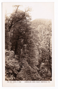
Postcard (item) - Black and white postcard, Rose Stereograph Company, Cumberland Creek Valley, Marysville, Vic, 1913-1967
A postcard in a series produced by the Rose Stereograph Company in Victoria, Australia as a souvenir of Marysville.A black and white photograph of a heavily forested valley leading up to a forested hill. The Cumberland Valley is near Cambarville which was a timber town near Marysville. Cambarville is notable for its giant mountain ash (Eucalyptus regnans) trees within the Cumberland Memorial Scenic Reserve, and relics from former sawmills and gold mining. The Big Culvert is located nearby on the Marysville - Woods Point Road, which was historically part of the Yarra Track. Cambarville was established as a timber mill town in the 1940s. Timber mill owners A Cameron and FJ Barton named Cambarville. They established the mill to salvage timber from trees destroyed in the 1939 bushfires. Cambarville was impacted by the 2009 Black Saturday bushfires and any remaining structures were destroyed.POST CARD The "Rose" Series/ De Luxe A Real Photograph/ Produced in Australia Published by the Rose Stereograph Co.,/ Armadale, Victoria.cumberland valley, marysville, victoria, p. 2330, cumberland creek, rose series postcard, postcard, souvenir, mountain ash, timber mill, mining, a cameron, fj barton, cambarville, big culvert, yarra track, black saturday bushfires, 1939 bushfires -
 Marysville & District Historical Society
Postcard (item) - Black and white postcard, Rose Stereograph Company, Cumberland Creek Valley, Marysville, Vic, 1913-1967
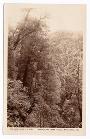
A postcard in a series produced by the Rose Stereograph Company in Victoria, Australia as a souvenir of Marysville.A sepia photograph of a heavily forested valley leading up to a forested hill. The Cumberland Valley is near Cambarville which was a timber town near Marysville. Cambarville is notable for its giant mountain ash (Eucalyptus regnans) trees within the Cumberland Memorial Scenic Reserve, and relics from former sawmills and gold mining. The Big Culvert is located nearby on the Marysville - Woods Point Road, which was historically part of the Yarra Track. Cambarville was established as a timber mill town in the 1940s. Timber mill owners A Cameron and FJ Barton named Cambarville. They established the mill to salvage timber from trees destroyed in the 1939 bushfires. Cambarville was impacted by the 2009 Black Saturday bushfires and any remaining structures were destroyed.POST CARD THE "ROSE"SERIES/ DE LUXE/ REAL PHOTOS PRODUCED IN/ AUSTRALIA Published by the Rose Stereographs/ Armadale, Victoriacumberland valley, marysville, victoria, p. 2330, cumberland creek, rose series postcard, postcard, souvenir, cambarville, mountain ash, mining, timber mills, big culvert, yarra track, a cameron, fj barton, black saturday bushfires, 1939 bushfires -
 Marysville & District Historical Society
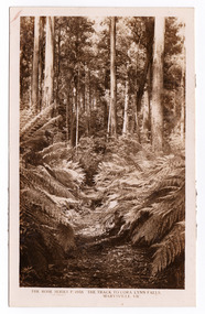
Postcard (item) - Black and white postcard, Rose Stereograph Company, The Track to Cora Lynn Falls, Marysville, Vic, 1913-1967
A postcard in a series produced by the Rose Stereograph Company in Victoria, Australia as a souvenir of Marysville.A black and white photograph of the track leading through the forest to the Cora Lynn Falls which is in the Cumberland Valley in Victoria. These falls are located on the Marysville-Wood's Point Road. Cambarville is notable for its giant mountain ash (Eucalyptus regnans) trees within the Cumberland Memorial Scenic Reserve, and relics from former sawmills and gold mining. The Big Culvert is located nearby on the Marysville-Woods Point Road, which was historically part of the Yarra Track. Cambarville was established as a timber mill town in the 1940s. Timber mill owners A Cameron and FJ Barton named Cambarville. They established the mill to salvage timber from trees destroyed in the 1939 bushfires. Cambarville was impacted by the 2009 Black Saturday bushfires and any remaining structures were destroyed. THE ROSE SERIES P. 4958/ COPYRIGHT/ THE TRACK TO CORA LYNN FALLS, MARYSVILLE, VIC. The reverse of postcard is illegible as it is covered by paper residue from when postcard was removed from an album. marysville, victoria, photograph, cora lynn falls, waterfalls, p. 4958, rose series postcard, rose stereograph company, souvenir, cambarville, marysville-wood's point road, eucalyptus regnans, cumberland memorial scenic reserve, mining, big culvert, yarra track, a cameron, fj barton, 1939 bushfires, 2009 black saturday bushfires, timber mills -
 Marysville & District Historical Society
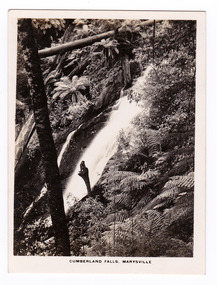
Photograph (item) - Black and white photograph, Rose Stereograph Company, Cumberland Falls, Marysville, 1913-1967
An early black and white photograph of Cumberland Falls near Marysville in Victoria.An early black and white photograph of Cumberland Falls near Marysville in Victoria. These falls are located on the Marysville-Wood's Point Road. Cambarville is notable for its giant mountain ash (Eucalyptus regnans) trees within the Cumberland Memorial Scenic Reserve, and relics from former sawmills and gold mining. The Big Culvert is located nearby on the Marysville - Woods Point Road, which was historically part of the Yarra Track. Cambarville was established as a timber mill town in the 1940s. Timber mill owners A Cameron and FJ Barton named Cambarville. They established the mill to salvage timber from trees destroyed in the 1939 bushfires. Cambarville was impacted by the 2009 Black Saturday bushfires and any remaining structures were destroyed. The photograph was also used to produce the Rose Series postcard P. 2328.marysville, victoria, photograph, waterfalls, cumberland falls, p. 2328, rose series postcard, souvenir, rose stereograph company, cambarville, marysville-wood's point road, mountain ash, eucalyptus regnans, cumberland memorial scenic reserve, mining, timber milling, big culvert, a cameron, fj barton, black saturday bushfires -
 Marysville & District Historical Society
Photograph (item) - Black and white photograph, Rose Stereograph Company, Track to Cora Lynn Falls, Marysville, 1913-1967
An early black and white photograph of the track to the Cora Lynn Falls in Marysville, Victoria.An early black and white photograph of the track to the Cora Lynn Falls in Marysville in Victoria. These falls are located on the Marysville-Wood's Point Road. Cambarville is notable for its giant mountain ash (Eucalyptus regnans) trees within the Cumberland Memorial Scenic Reserve, and relics from former sawmills and gold mining. The Big Culvert is located nearby on the Marysville - Woods Point Road, which was historically part of the Yarra Track. Cambarville was established as a timber mill town in the 1940s. Timber mill owners A Cameron and FJ Barton named Cambarville. They established the mill to salvage timber from trees destroyed in the 1939 bushfires. Cambarville was impacted by the 2009 Black Saturday bushfires and any remaining structures were destroyed. The photograph was also used to produce the Rose Series postcard P. 4958.marysville, victoria, photograph, cora lynn falls, waterfalls, p. 4958, rose series postcard, rose stereograph company, souvenir, cambarville, marysville-wood's point road, eucalyptus regnans, cumberland memorial scenic reserve, mining, big culvert, yarra track, a cameron, fj barton, 1939 bushfires, 2009 black saturday bushfires, timber mills -
 Marysville & District Historical Society
Photograph (item) - Black and white photograph, Rose Stereograph Company, Cora Lynn Falls, Marysville, 1913-1967
An early black and white photograph of the Cora Lynn Falls near Marysville in Victoria.An early black and white photograph of the Cora Lynn Falls near Marysville in Victoria. These falls are located on the Marysville-Wood's Point Road. Cambarville is notable for its giant mountain ash (Eucalyptus regnans) trees within the Cumberland Memorial Scenic Reserve, and relics from former sawmills and gold mining. The Big Culvert is located nearby on the Marysville - Woods Point Road, which was historically part of the Yarra Track. Cambarville was established as a timber mill town in the 1940s. Timber mill owners A Cameron and FJ Barton named Cambarville. They established the mill to salvage timber from trees destroyed in the 1939 bushfires. Cambarville was impacted by the 2009 Black Saturday bushfires and any remaining structures were destroyed. The photograph was also used to produce the Rose Series postcard P. 4947.marysville, victoria, photograph, cora lynn falls, waterfalls, rose series postcard, rose stereograph company, souvenir, cambarville, marysville-wood's point road, eucalyptus regnans, cumberland memorial scenic reserve, mining, big culvert, yarra track, a cameron, fj barton, 1939 bushfires, 2009 black saturday bushfires, timber mills, p. 4947 -
 Marysville & District Historical Society
Postcard (item) - Black and white postcard, Rose Stereograph Company, Cumberland-Cora Lynn Trip, Marysville, Vic. At the Meeting of the Waters, 1913-1967
A postcard in a series produced by the Rose Stereograph Company in Victoria, Australia.A black and white photograph of the Cora-Lynn waterfalls at the Meeting of the Waters near the Cumberland Creek. These falls are located on the Marysville-Wood's Point Road. Cambarville is notable for its giant mountain ash (Eucalyptus regnans) trees within the Cumberland Memorial Scenic Reserve, and relics from former sawmills and gold mining. The Big Culvert is located nearby on the Marysville-Woods Point Road, which was historically part of the Yarra Track. Cambarville was established as a timber mill town in the 1940s. Timber mill owners A Cameron and FJ Barton named Cambarville. They established the mill to salvage timber from trees destroyed in the 1939 bushfires. Cambarville was impacted by the 2009 Black Saturday bushfires and any remaining structures were destroyed. This postcard was produced by the Rose Stereograph Company as a souvenir of Marysville.POST CARD. Correspondence/ Addresscora lynn falls, waterfalls, cumberland valley, cumberland creek, marysville, victoria, southern cross series, 4938, postcard, souvenir, meeting of the waters, marysville-wood's point road, cambarville, eucalyptus regnans, big culvert, cumberland memorial scenic reserve, a cameron, fj barton, 1939 bushfires, 2009 black saturday bushfires, rose stereograph company